Cyclone Fina causes extensive flooding of the Lower Adelaide River floodplain
The Department of Lands, Planning and Environment (Department) is developing a water allocation plan for the Adelaide River catchment. The water plan will provide the rules for sharing water – including for public water supply (drinking, washing and homes), and water for economic development (supporting jobs and businesses).
The plan will be informed by science and the local community, including the Adelaide River water advisory committee.
On Saturday 22 November, severe tropical Cyclone Fina passed around 50 km north of Darwin, bringing damaging winds and heavy rainfall to the region, including the Adelaide River floodplain.
Middle Point rain gauge in the Lower (northern) Adelaide River catchment, a few kilometres north of Arnhem Highway, recorded 470mm of rain from 9am Friday 21 November to 9am Sunday 23 November.
The response of the Lower Adelaide River floodplain after Cyclone Fina is an interesting case study for how the catchment behaves.
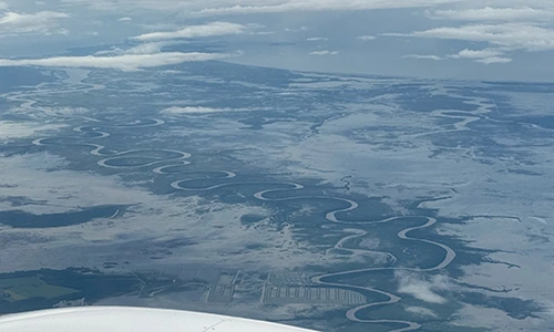
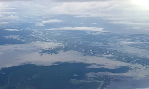
The Department captured aerial imagery of the Lower Adelaide River floodplain on Sunday 23 November.
The images show separation between water on the floodplain and the main Adelaide River channel, demonstrating floodplain inundation is mostly driven by localised rainfall and runoff onto the floodplain, rather than from overbank flows from the river. This is significant for hydrologists and water planners in their understanding of the catchment.
The Department scientists have provided information to explain what we are seeing on the floodplain. The top of the bank level of the Adelaide River at the Arnhem Highway Bridge is 2.0 metres Australian Height Datum (AHD - which is a similar measure to metres above sea level). The floodplain areas sit lower than the riverbanks, down to 1.2m AHD.
The river briefly exceeded the 2m AHD bank level at the peak of the high tide by less than 100mm on the day of the cyclone, however the period of exceedance was very short. This is insufficient to allow widespread flooding and lateral connectivity between the river and its floodplain. That is, the water on the floodplain was from the rain falling directly on the floodplain, and not from the river flowing across the floodplain.
The floodplain inundation is captured in the imagery below.
Read about the progress of the water plan development at Adelaide River water allocation plan | NT.GOV.AU
Recap on the progress of the advisory committee at Adelaide River Water advisory committee meetings.
For more information, email us at waterresources.dlpe@nt.gov.au.
Humpty Doo Barra at the bottom of screen, Lower Adelaide River floodplain to the Arafura Sea. Photo provided by Lynda Shappert
Extensive floodplain inundation caused by the rain from Cyclone Fina